


Home


ACRE NEWS
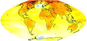
ACRE data helps confirm
global warming
For the first time, ACRE data have been used to independently show that global warming is real.
ANALYSIS PARTNERS
Partnerships
are
an
essential
way
ACRE
does
business.
Nine
core
climate
research
partners
provide
funding
or
‘in
kind’
support
and
undertake
key
parts
of
ACRE’s
activities
while
linkages
are
maintained
with
numerous
other
climate
research
organisations
and
various
institutions
around
the
globe.

MEETINGS
7th ACRE workshop at
Environment Canada
This meeting will address the further uptake of 20CR, ERA- 20C and EURO4M/EURRA outputs and products by the climate science community (and more!)


WHAT IS ACRE
The
international
Atmospheric
Circulation
Reconstructions
over
the
Earth
(ACRE)
initiative
works
to
retrieve
our
global
climate
history.
It
harnesses
the
work
of
many
professionals
and
volunteers
to
recover
historical
terrestrial
and
marine
weather
observations.
Project
members
search
out
millions
of
documents,
typically
paper-based,
convert
them
to
electronic
images
and
then
digitise
the
useful
data
they
contain.
The
data
supports
computer-based
4D
weather
recon-
structions
(reanalyses)
spanning
the
last
200-250
years.
Climate
applications
and
analyses
of
climate
impacts
worldwide
benefit
from
the
work
of
the
ACRE
initiative.
All
of
the
historical
surface
weather
data
and
the reanalyses are freely available.
ACRE achieves its mission by:
•
linking international meteorological
organisations & data rescue infrastructures;
•
facilitating the recovery, extension, quality
control & consolidation of global historical
terrestrial & marine instrumental surface data
covering the last 250 years;
•
making these observations available to all
international reanalyses;
•
ensuring that 4D reanalysis products can be
tailored/downscaled to flow into various climate
applications & production models.
•
providing access to tools and techniques for
analyses and interpretation of historical
documentary weather observations.


DATA PARTNERS
ACRE
maintains
a
strong
regional
presence
across
the
globe
to
recover,
image,
digitise
and
archive
local
climate
data
covering
all
continents
and
oceans.
Citizen
scientists
have
an
important role to play.